
Africa
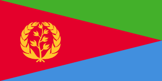
Eritrea sits in the Horn of Africa, bordered by Sudan to the west, Ethiopia to the south, and Djibouti to the southeast, with a long coastline on the Red Sea.
Eritrea's name comes from the Greek 'Erythraia,' meaning 'red,' referring to the Red Sea, which forms the country's entire eastern coastline.
Landscape: Includes a central highland plateau, a hot coastal lowland along the Red Sea, and part of the Danakil Depression, one of the hottest places on Earth.
Climate: Varies dramatically by elevation, cooler in the highlands, extremely hot along the coast and in the Danakil Depression.
Food: Injera served with a spiced stew called tsebhi is the everyday staple, closely related to Ethiopian cuisine.
Asmara developed significantly under Italian colonial rule in the early 20th century, which left the city with a remarkably well-preserved collection of Art Deco and modernist architecture, earning it recognition as a UNESCO World Heritage Site. With a population of around 900,000, it remains Eritrea's political and cultural centre.
The camel appears prominently in Eritrean rural and pastoral tradition, particularly among the country's lowland communities, and the olive branch, referencing peace after a long war for independence from Ethiopia, appears on the national emblem.
Eritrean silver and gold filigree jewellery-making has deep roots tied to the region's historic trade routes, and traditional Eritrean basket weaving, using dyed straw in intricate patterns, remains a significant craft export. Traditional Eritrean coffee ceremony, involving roasting and preparing beans in front of guests, remains a genuinely significant daily and ceremonial social practice. Traditional Eritrean woven baskets, known as agelgil, are used both decoratively and practically for carrying food at celebrations.
Asmara's well-preserved Italian colonial-era architecture, sometimes called 'Piccola Roma' (Little Rome), is the country's most internationally distinctive landmark, an unusually intact collection of early 20th-century modernist buildings.
Eritrea's Dahlak Archipelago in the Red Sea supports significant coral reef systems and marine biodiversity, relatively undeveloped compared to more heavily touristed parts of the Red Sea further north. Eritrea's highlands support klipspringers and other small antelope species adapted to its rugged mountainous terrain.
Eritrea is roughly evenly split between Christian and Muslim populations, and the country fought a long and difficult 30-year war for independence from Ethiopia, achieved in 1993, which remains deeply significant to national identity.
Eritrea is a modest exporter of minerals, including gold and other metals, alongside livestock, though the country's formal trade economy remains relatively limited and underdeveloped.
Independence Day on May 24th marks 1993, when Eritrea formally gained sovereignty from Ethiopia following a 30-year armed struggle, one of the longest independence wars of the 20th century. Given Eritrea's roughly even split between Christian and Muslim populations, both Christmas and Eid holidays are widely observed. Eritrea's Martyrs' Day in June honours those who died during the 30-year independence struggle.
Cycling holds a genuinely unique place in Eritrean sporting culture, a legacy of Italian colonial influence, the country having produced the first Black African cyclist to compete in and complete the Tour de France. Football and long-distance running, following the wider East African tradition, also draw significant domestic followings. Eritrean athletics has also produced notable distance runners following the wider East African tradition.
Eritrea is a one-party state, with a President who has held power continuously since independence in 1993, and no national elections have been held since that time. The country is often described as one of the most restrictive and least internationally transparent governments in the world, with an indefinite national conscription system that has driven significant emigration. Eritrea's indefinite national service system has been a significant factor driving emigration from the country. Eritrea maintains one of the lowest internet penetration rates in the world, reflecting its restrictive governance.
Emba Soira is Eritrea's highest point at 3,018 metres. The Kobar Sink, part of the Danakil Depression, holds the lowest point at around 75 metres below sea level. Eritrea's terrain ranges dramatically from highland plateau to some of the hottest lowland desert on Earth.
There's no especially close match for Eritrea's flag, the red triangle bearing a golden olive wreath and branch, flanked by green and blue triangles, is a distinctive combination, that specific colour and shape arrangement not closely replicated by any other current national flag. Eritrea's olive wreath emblem is distinct from the crescent-and-star symbolism used by several neighbouring nations.
Adopted in 1993 upon independence from Ethiopia, based on the flag used by the Eritrean People's Liberation Front during the decades-long war for independence.
Home to one of the hottest inhabited places on Earth, the Danakil Depression.
Play today's Flagpie →© Flagpie 2026